

Panorado Flyer
version 1.2 |  windows
windows
Name: Panorado Flyer
Version: 1.2
Size: 228.35 KB
Category: Digital Photo Tools
License: Free
Released: 2007-06-09
Developer: Karl Maloszek - Simple Software
Downloads: 954
Version: 1.2
Size: 228.35 KB
Category: Digital Photo Tools
License: Free
Released: 2007-06-09
Developer: Karl Maloszek - Simple Software
Downloads: 954
| Rate this software: |

exe | 228.35 KB
Description
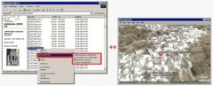
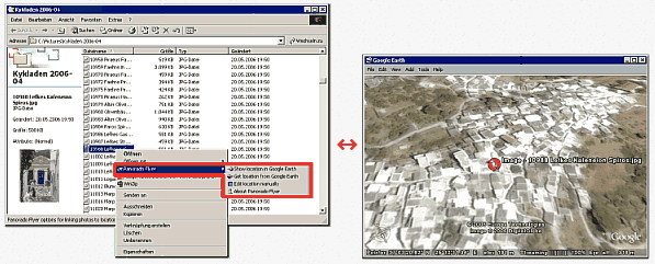
Panorado Flyer is a simple geocoding tool for linking JPEG image files to the location where the picture was taken, using precise geographical coordinates. It can be lauched from the Windows Explorer's context menu. The coordinates of the place where the photo was taken are stored within the JPEG file in EXIF format - either manually or automatically from Google Earth. Later, you'll be able to let Google Earth 'fly' you the location again! If multiple images are selected, the resulting satellite view will include the locations of all images! Screenshots

Similar Software
PhotoWipe WebCacheImageInfo Pictuck EasyPhototools 2.0.0.0Image and Photo Gallery Software 2.5HP Photo Creations 2.6FoxArc Screen Capture On-screen Ruler 2.2.0.0PhotoOnWeb Album Creator Exif wMarker 2.0.0ProStockMaster for Windows 2.0.3Smugmug Uploader Photos On Canvas Print calculator ImageCool 2013 3.20.130330TinyPic 3.18


